
Red rock country-Sedona is a wonderland of red sandstone formations. Located just below the Mogollon Rim, Sedona is about 30 miles south of Flagstaff and about 100 miles north of Phoenix, Arizona.
Photographs of red rock country-Sedona
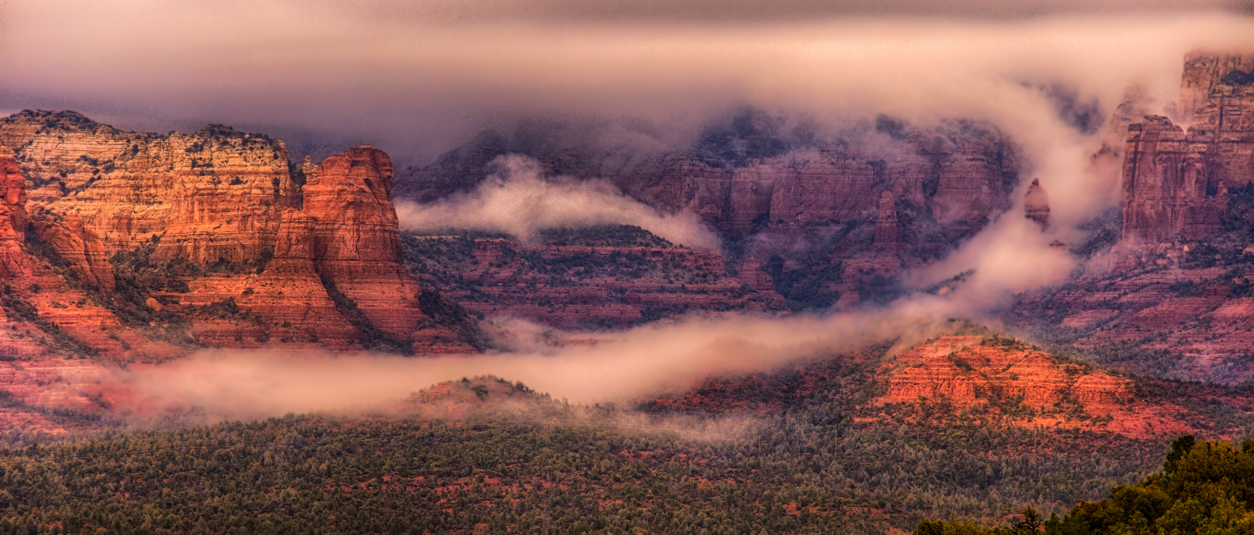
Here are photos of the magnificent geology that surrounds the beautiful little town of Sedona:


Why is Sedona special?
The red rock country surrounding Sedona provides many opportunities for the photographer. Because of its location just off the Moggolon Rim, photographers will frequently find fog draping over the red rocks in the early morning. And, in the late afternoon, photographers can take advantage of brilliant sunsets and intense alpenglow.
Places to visit around Sedona
Here are some of our favorite places around Sedona:
- To the north is Schnebley Hill Road. This dirt road winds up onto the Mogollon Rim and eventually joins I-17. Closer to town, there are beautiful vistas back toward Sedona from several overlooks and rock formations. One of the nicest is Vista Overlook and the Carousel.
- Several walking trails are south of town, just off Highway 179, also called the Red Rock Scenic Byway. One of the nicest trails is the Bell Rock Pathway. This trail circumnavigates Bell Rock and has beautiful views all along the way.
- East of town is a network of jeep roads and trails. In order to travel these roads, you need a high clearance, four-wheel drive vehicle. However, it is definitely worth the added effort. One of the fun destinations is Submarine Rock, a peninsula of sandstone jutting into a valley.
- Finally, west of town, off Vultee Road, is Devil’s Bridge. A little closer in to town is Devil’s Kitchen, Seven Sacred Pools, and Soldier’s Arch.
Here is a link to a site to help you plan your travels around this area.
A little about the red rock geology
Located just below the Mogollon Rim, Sedona is in the transition area between the Colorado Plateau to the northeast and the Basin and Range area to the southwest. And, the geologic history of the region is a story of deposition, uplist, and erosion. For download, the Arizona Geological Survey offers A Guide to the Geology of the Sedona & Oak Creek Canyon area, Arizona.
To purchase our photos
To license a photo or purchase a print, contact us using the form to the right and we will do our best to accommodate your needs.
Wow the pics are just amazing. I think these are one of the best pictures of this area of Sedona I have ever seen. I am visiting Sedona in 2 weeks. Could you tell me which location on the airport road you took some of these pics from? I am planning to go there for sunrise. Thank you 🙂
It’s not that long a road. There are several places along it to pull off and park – and I stopped at each one on various mornings and evenings. Each spot gives you a different view. Why not scout it during the middle of the day so that you can be ready for sunset and sunrise.