
Dinosaur National Monument straddles the border between Utah and Colorado, near the confluence of the Green and Yampa Rivers. Mostly in Colorado, there are so many wonders packed into an area of roughly 330 square miles. Consequently, it is a premiere destination for photographers.
Photos from Dinosaur National Monument
Here is a selection of photographs we have taken on our many trips to Dinosaur National Monument. We have organized the photos by the main areas in and near the National Monument. (Note: Photos of petroglyphs are covered in a separate post.) Photo locations are:
Cub Creek
Harpers Corner
Echo Park
Yampa Bench
Island Park
Gates of Lodore
Around Dinosaur
Cub Creek Area Photos
The Cub Creek area includes Cub Creek Road, as well as the access road to Split Mountain Campground and the road to the Josie Morris Ranch.


Harpers Corner Area Photos
The Harpers Corner area includes Harpers Corner Road and overlooks, as well as Moffat County Road 16 (Blue Mountain Road) and the Harpers Corner Trail.


Echo Park Area Photos
The Echo Park area encompasses the sights along Echo Park Road, as well as the main event—Echo Park. Echo Park road is dirt and crosses many washes. For the most part, the road isn’t too bad. However, parts of the road are impassible when it rains.


Along the Yampa Bench Road
The Yampa Bench Road (also a dirt road) peels off the Echo Park Road after about 8 miles. It follows the Yampa River eastward for about 10 miles. Along this stretch of road are three spectacular overlooks.


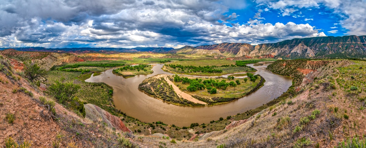
Island Park Road
The Island Park Road (graded dirt) enters Dinosaur National Monument on the west side, near McKee Springs. It provides access to the McKee Springs petroglyphs, Rainbow Park, Island Park, and Ruple Ranch. Here is a photo of Island Park.
The Gates of Lodore
The Gates of Lodore is in the northernmost part of Dinosaur National Monument. It is the put-in point for most rafting trips down the Green River to Split Mountain. You can get there by heading northwest from Maybell, Colorado, on CO 318. And then, you turn right onto Moffat County Road 34, which takes you to the ranger station and campground.


Photographing in Dinosaur NM
Dinosaur National Monument is home to grand landscapes, geologic wonders, ancient ruins, petroglyphs, and dinosaur fossils. There is something for everyone. However, Dinosaur is one of those parks where you hear people say, “You can’t get there from here.” There are four paved roads that provide access to the park — from four different directions. Once in the park, several high-clearance dirt roads take you further into the interior.
So, to make the most of your visit and find that perfect shot, you will need to do some planning. For instance, what will be the best time to photograph the canyons, the petroglyphs, or the rock formations? Are the dirt roads passable? Should you go at dawn, sunset, or sometime in between? Where can you get fuel and other necessities.
The NPS Dinosaur Website will answer most of your questions. It has the latest information about closures, current road conditions, and available tours. If you go to the maps section, there is a nice interactive map that shows the available roads, what they require, and the sights along the way.
Other places around Dinosaur NM
Dinosaur National Monument is not the only destination in this area. Be sure to visit Red Fleet State Park, Fantasy Canyon, and the Utah Field House of Natural History State Park in Vernal. Here are some photos from around Dinosaur.


Red Fleet State Park
Ten miles north of Vernal, Utah, is Red Fleet State Park. When seen against the horizon, the red sandstone formations of the park look like a fleet of ships sailing in the sky. Learn more about the park at https://stateparks.utah.gov/parks/red-fleet/.
Fantasy Canyon
Fantasy Canyon is an erosional landscape that is about 25 mile south of Vernal, Utah. Fanciful formations fill this small area of about a square mile. Here is information about the geology of this area.
Utah Field House
The Utah Field House of Natural History in Vernal, Utah, is one of the best places in the state to see dinosaur fossils. If you have the time, it is definitely worth the visit. To plan that visit, be sure to look at the Utah Field House of Natural History State Park Website. Not only will it introduce you to the current exhibits, but also entice you to come participate in one of their paleontology field projects.
Purchasing our photographs
All of our scenic photographs are available as fine art prints. Use the contact form to the right to get more information. Or, go to our Fine Art Print page to learn about various pricing options.
Back to top